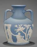
Sold for:
$175

John Speed (English, 17th century, also known as Iohan Speede). "The West Ridinge of Yorkeshyre with The Most Famous and Fayre Citie Yorke Described. 1610", cartographical engraving, published by Bassett and Chiswell in 1676. Map inscribed to lower left within cartouche "Performed by Iohan Speede, And are to be solde in Popes heade alley, against the Exchange, by Iohn Sudbury and George Humbell at the white horse. Cum privilegio Regis. Anno Domini 1610". Printing in Latin to verso of page titled "Occidentalis Eboracensis Comitaus Pars (The Western Portion of York County)" and listing names below. Sheet approximately 16.25" x 21.25".


Ahlers & Ogletree Auction Gallery

Auctioneer:
Ahlers & Ogletree Auction Gallery

Date:
2015-03-22

Archived auctions similar to J. Speed 1610 Map "The West Ridinge of Yorkeshyre" Down arrow


Sold for:
$246

Ireland, Leinster County, Dublin. John Speed (1552-1629) The Countie of Leinster with the Citie Dublin Described. London: Chiswell and Basset, [no date]. Double page folio Read more…


Auctioneer:
Skinner

Date:
2017-11-12


Sold for:
$1,169

Webster, John (1610-1682) The Displaying of Witchcraft. Wherein is affirmed that there are many sorts of Deceivers and Impostors . London: printed by J.M. Read more…


Auctioneer:
Skinner

Date:
2014-11-16


Sold for:
$519

1610 (but 1611), hand-colored. The first map of the Isle of Man alone and the first based on an actual survey, performed by Thomas Durham Read more…


Auctioneer:
Leslie Hindman Auctioneers

Date:
2009-11-19


Sold for:
$3,000

"Novi Belgii Novaeque Angliae Nec Non partis Virginiae Tabula"--1656, hand colored engraved map, second state. Antique map depicting early view of America (or New Netherlands) Read more…


Auctioneer:
Ahlers & Ogletree Auction Gallery

Date:
2014-08-10


Sold for:
$150

19th century, American Civil War wall map mounted in a glazed frame with original wooden dowel scroll form paper map. Antique map reads at top Read more…


Auctioneer:
Ahlers & Ogletree Auction Gallery

Date:
2013-11-03


Sold for:
$369

Mitchell's National Map of the American Republic or United States of North America. Philadelphia: S. Augustus Mitchell, 1843. Large wall map mounted on linen and Read more…


Auctioneer:
Skinner

Date:
2017-11-12


Sold for:
$180

Cary, John (c. 1754-1835) Cary's New Map of England and Wales with Part of Scotland . London: Publish'd June 11th 1794 by J. Cary, Read more…


Auctioneer:
Skinner

Date:
2013-06-01


Sold for:
$40

J. ANDRIVEAU-GOUJOU, HAND COLORED MAP OF THE WORLD, 1856, 16 1/2" X 23", "PLANISPHERE TERESTRE":Paris 1856; from "Atlas Universel No. 12"; framed. Read more…


Auctioneer:
Dumouchelle Art Galleries

Date:
2008-09-14


Sold for:
$764

Benjamin's New Map of the Hudson River, "Published by J.P. Benjamin of the Steam-Boat Troy," 1845, the map showing the Hudson River from the Lake Read more…


Auctioneer:
Skinner

Date:
2006-11-04


Sold for:
5,175 CHF

J. Auricoste à Paris, No. 554, circa 1930. Fine mahogany 49 hour going marine chronometer with power reserve indication and electric impulse contactors. Read more…


Auctioneer:
Antiquorum

Date:
1994-10-15